Atlit
Atlit עַתְלִית عتليت | |
|---|---|
| Transkripsi Ibrani | |
| • tidak resmi | Atlith |
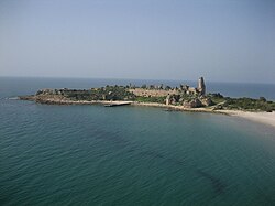 Benteng Atlit | |
  Atlit  Atlit | |
| Koordinat: Lua error in package.lua at line 80: module 'Module:ISO 3166/data/IL' not found. | |
| Grid position | dulunya 144/234, sekarang 144/232 PAL |
| Negara | |
| Distrik | Haifa |
| Dewan | Hof HaCarmel |
| Didirikan | 6900 SM (Atlit Yam) 1296 (desa Tatar) 1596 (desa Arab)[1] 1903 (pemukiman desa Yahudi) 1948 (desa Israel) |
| Populasi (2018)[2] | 8.047 |
Atlit (Ibrani: עַתְלִית) adalah sebuah kota pesisir yang terletak di selatan Haifa, Israel. Komunitas berada dalam Dewan Regional Hof HaCarmel di Distrik Haifa, Israel. Sebuah desa Yahudi didirikan pada 1903 di bawah naungan Baron Edmond de Rothschild, yang digabungkan ke dalam kota Palestina abad pertengahan.
Referensi
- ^ https://www.arab48.com/%D9%85%D8%AD%D9%84%D9%8A%D8%A7%D8%AA/%D8%AF%D8%B1%D8%A7%D8%B3%D8%A7%D8%AA-%D9%88%D8%AA%D9%82%D8%A7%D8%B1%D9%8A%D8%B1/2018/04/16/%D8%B9%D8%AA%D9%84%D9%8A%D8%AA-%D8%A7%D9%84%D8%A3%D8%B1%D8%B6-%D9%88%D8%A7%D9%84%D8%B0%D8%A7%D9%83%D8%B1%D8%A9-
- ^ "Population in the Localities 2018" (XLS). Israel Central Bureau of Statistics. 25 August 2019. Diakses tanggal 26 August 2019.
Daftar pustaka
- Barron, J. B., ed. (1923). Palestine: Report and General Abstracts of the Census of 1922. Government of Palestine.
- Conder, C.R.; Kitchener, H.H. (1881). The Survey of Western Palestine: Memoirs of the Topography, Orography, Hydrography, and Archaeology. 1. London: Committee of the Palestine Exploration Fund. p. 281
- Department of Statistics (1945). Village Statistics, April, 1945. Government of Palestine.
- Hartmann, M. (1883). "Die Ortschaftenliste des Liwa Jerusalem in dem türkischen Staatskalender für Syrien auf das Jahr 1288 der Flucht (1871)". Zeitschrift des Deutschen Palästina-Vereins. 6: 102–149.
- Hadawi, S. (1970). Village Statistics of 1945: A Classification of Land and Area ownership in Palestine. Palestine Liberation Organization Research Center. Diarsipkan dari versi asli tanggal 2018-12-08. Diakses tanggal 2014-11-08. Parameter
|url-status=yang tidak diketahui akan diabaikan (bantuan) - Irby, C.L.; Mangles, J. (1823). Travels in Egypt and Nubia, Syria, and Asia Minor; during the years 1817 & 1818. London: Printed for Private Distribution by T. White & Co. Irby and Mangles, 1823, p. 191
- Khalidi, W. (1992). All That Remains: The Palestinian Villages Occupied and Depopulated by Israel in 1948. Washington D.C.: Institute for Palestine Studies. ISBN 0-88728-224-5.
- Karmon, Y. (1960). "An Analysis of Jacotin's Map of Palestine" (PDF). Israel Exploration Journal. 10 (3,4): 155–173; 244–253. Diarsipkan dari versi asli (PDF) tanggal 2019-12-22. Diakses tanggal 2020-07-20.
- Mills, E., ed. (1932). Census of Palestine 1931. Population of Villages, Towns and Administrative Areas. Jerusalem: Government of Palestine.
- Morris, B. (2004). The Birth of the Palestinian Refugee Problem Revisited. Cambridge University Press. ISBN 978-0-521-00967-6.
- Palmer, E. H. (1881). The Survey of Western Palestine: Arabic and English Name Lists Collected During the Survey by Lieutenants Conder and Kitchener, R. E. Transliterated and Explained by E.H. Palmer. Committee of the Palestine Exploration Fund.
- Schumacher, G. (1888). "Population list of the Liwa of Akka". Quarterly Statement - Palestine Exploration Fund. 20: 169–191.
- Socin, A. (1879). "Alphabetisches Verzeichniss von Ortschaften des Paschalik Jerusalem". Zeitschrift des Deutschen Palästina-Vereins. 2: 135–163.
Pranala luar
- Official Atlit Community Website
- Welcome To 'Atlit
- 'Atlit, from Zochrot
- Survey of Western Palestine, Map 5: IAA, Wikimedia commons


