Wingene
Municipality in Flemish Community, Belgium

Flag

Coat of arms
Location of Wingene


Wingene
Location in Belgium 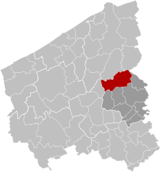
Location of Wingene in West Flanders

 Belgium
 (2018-01-01)[1]
8750
37018
Wingene (Dutch pronunciation: [ˈʋɪŋənə]; West Flemish: Wiengne; historically: Wynghene) is a municipality located in the Belgian province of West Flanders. The municipality comprises the towns of Wingene proper and Zwevezele. On December 1, 2019, Wingene had a total population of 14,398. The total area is 68.42 km2 which gives a population density of 192 inhabitants per km2.
Gallery
-
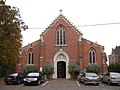 Saint George's church, Wildenburg, Wingene
 -
 Restored coach house of the former castle of Zwevezele


References
- ^ "Wettelijke Bevolking per gemeente op 1 januari 2018". Statbel. Retrieved 9 March 2019.
External links
 Media related to Wingene at Wikimedia Commons


- v
- t
- e

- Bold indicates cities
- Italic indicates Municipalities with language facilities
Authority control databases | |
|---|---|
| International |
|
| Geographic |
|
 | This West Flanders location article is a stub. You can help Wikipedia by expanding it. |
- v
- t
- e


