Seikkyi Kanaungto Township
Township of Yangon in Myanmar
Seikkyi Kanaungto Township ဆိပ်ကြီးခနောင်တို မြို့နယ် | |
|---|---|
Township of Yangon | |
| Seikkyi Kanaungto Township | |
| 16°45′30″N 96°7′0″E / 16.75833°N 96.11667°E / 16.75833; 96.11667 | |
| Country | Myanmar |
| Division | Yangon |
| City | Yangon |
| Township | Dawbon |
| Area | |
| • Total | 5.9 km2 (2.26 sq mi) |
| Population (2000)[1] | |
| • Total | 21,000 |
| • Density | 3,600/km2 (9,300/sq mi) |
| Time zone | UTC6:30 (MST) |
| Postal codes | 11271 |
| Area code(s) | 1 (mobile: 80, 99) |
| YCDC[1] | |
Seikkyi Kanaungto Township (Burmese: ဆိပ်ကြီးခနောင်တို မြို့နယ် [sʰeɪʔtɕí kʰənàʊɰ̃tò mjo̰nɛ̀]) is located on the southwestern bank of Yangon river across from downtown Yangon, Myanmar. The township comprises eight wards, and is bounded by the Yangon river in the north, the Twante Canal in the east, and Twante Township in the south and west. The township is still largely rural and undeveloped mainly because it still lacks a bridge across the Yangon river to downtown.
Seikkyi Kanaungto has 16 primary schools, and one high school.[1]
References
- ^ a b c "Dawbon Township". Yangon City Development Committee. Archived from the original on 2 October 2011. Retrieved 2009-03-21.
- v
- t
- e
Districts/Townships of Yangon
Capital: Yangon
- Botataung Township
- Dagon Seikkan Township
- East Dagon Township
- North Dagon Township
- North Okkalapa Township
- Pazundaung Township
- South Dagon Township
- South Okkalapa Township
- Thingangyun Township
- Dawbon Township1
- Mingala Taungnyunt Township1
- Tamwe Township1
- Thaketa Township1
- Yankin Township1
- Dala Township
- Seikkyi Kanaungto Township
- Cocokyun Township
- Kawhmu Township
- Kayan Township
- Kungyangon Township
- Kyauktan Township
- Thanlyin Township
- Thongwa Township
- Twante Township
- Tada Subtownship
(Downtown)
1 - part of South Yangon City; 2 - part of North Yangon City
| ||
|---|---|---|
Capital: Yangon | ||
| East Yangon District |  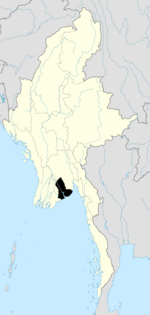 | |
| North Yangon District | ||
| South Yangon District |
| |
| West Yangon District (Downtown) | ||
| Main cities and towns | ||
1 - part of South Yangon City; 2 - part of North Yangon City | ||


