Pednathise Head
49°51′48″N 6°24′10″W / 49.8634°N 6.4027°W / 49.8634; -6.4027
United Kingdom

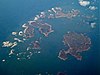
Pednathise Head is a skerry that is the southernmost point of England, the United Kingdom, and the British Isles if the Channel Islands are excluded. It is part of the Western Rocks group of the Isles of Scilly, southwest of Cornwall.
 Cornwall portal

- v
- t
- e
Isles of Scilly
- St Mary's
- St Agnes (and Gugh)
- Bryher
- Tresco
- St Martin's
- St Mary's: Hugh Town, Holy Vale, Longstone, Maypole, Normandy, Old Town, Pelistry, Porthloo, Rocky Hill, Telegraph and Trenoweth
- St Martin's: Higher Town, Middle Town and Lower Town
- St Agnes: Middle Town
- Tresco: New Grimsby and Old Grimsby
- Environment
- History
- People
- Transport
 | This article about a location in the Isles of Scilly, Cornwall is a stub. You can help Wikipedia by expanding it. |
- v
- t
- e


