Peak to Peak Scenic Byway
Scenic road in Colorado, United States
Peak to Peak Scenic Byway National Forest Scenic Byway | |
|---|---|
| Route information | |
| Maintained by CDOT | |
| Length | 55 mi[1][2] (89 km) |
| Existed | 1989–present |
| Major junctions | |
| South end |  SH 119 Black Hawk SH 119 Black Hawk |
| North end |    US 34 / US 36 / SH 7 Estes Park US 34 / US 36 / SH 7 Estes Park |
| Location | |
| Country | United States |
| State | Colorado |
| Counties | Gilpin, Boulder, Larimer counties |
| Highway system | |
| |


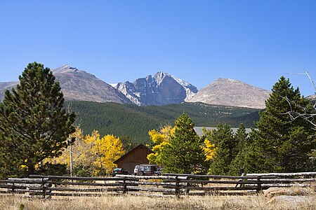
The Peak to Peak Scenic Byway is a 55-mile (89 km) National Forest Scenic Byway and Colorado Scenic and Historic Byway located in Gilpin, Boulder, Larimer counties, Colorado, USA. The Peak to Peak Highway was originally built in 1918[3] and provides views of the Front Range mountains in the Colorado Rocky Mountains. It was Colorado's first scenic highway. The Central City/Black Hawk Historic District is a National Historic Landmark.
The Peak to Peak Highway connects to the Trail Ridge Road/Beaver Meadow National Scenic Byway at Estes Park.
Route
Parks & Recreation Areas
- Rocky Mountain National Park
- Golden Gate Canyon State Park
- Arapaho National Forest
- Roosevelt National Forest
- Indian Peaks Wilderness
Mountain peaks
- Mount Flora
- Mount Eva
- Mount Epworth
- Mount Jasper
- Apache Peak
- Mount Audubon 13,229 feet (4,032 m)
- Meadow Mountain
- Copeland Mountain
- Mount Meeker 13,916 feet (4,242 m)
- Longs Peak 14,259 feet (4,346 m)
- Twin Sisters Peaks
Gallery
-
 Aspen Trees on the Peak to Peak
 -
-
 Chapel on the Rock (officially, Saint Catherine of Siena Chapel)


See also
 History portal
 U.S. Roads portal
 Colorado portal
Notes
References
- ^ "Peak to Peak". Colorado Department of Transportation. 2021. Retrieved April 8, 2022.
- ^ "Peak to Peak Scenic and Historic Byway". America's Scenic Byways. Retrieved April 8, 2022.
- ^ Colorado Department of Transportation. "Peak To Peak". Colorado Department of Transportation.
External links
Colorado at Wikipedia's sister projects
 Media from Commons
 News from Wikinews
 Quotations from Wikiquote
 Travel information from Wikivoyage
- America's Scenic Byways: Colorado
- Colorado Department of Transportation
- Colorado Scenic & Historic Byways Commission
- Colorado Scenic & Historic Byways
- Colorado Travel Map
- Colorado Scenic & Historic Byways Commission
- Colorado Tourism Office
- History Colorado
- National Forest Scenic Byways
- v
- t
- e
Denver (capital)
- Bibliography
- Index
- Outline
- Climate change
- Colleges
- Coloradans
- Elections
- Federal lands
- Geography
- Government
- Historic places
- History
- Images
- Indian reservations
- Law
- Lists
- Military
- Mountains
- Municipalities
- Museums
- National Forests
- National Parks
- Paleontology
- Prehistoric sites
- Prehistory
- Protected areas
- Railroads
- Rivers
- Slavery
- Statistical areas
- Symbols
- Timeline
- Tourist attractions
- Towns
- Trails
- Transportation
- Wildernesses
- Alamosa
- Arvada
- Aspen
- Aurora
- Black Hawk
- Boulder
- Brighton
- Broomfield
- Brush
- Burlington
- Cañon City
- Castle Pines
- Centennial
- Central City
- Cherry Hills Village
- Colorado Springs
- Commerce City
- Cortez
- Craig
- Cripple Creek
- Dacono
- Delta
- Denver
- Durango
- Edgewater
- Englewood
- Evans
- Federal Heights
- Florence
- Fort Collins
- Fort Lupton
- Fort Morgan
- Fountain
- Fruita
- Glendale
- Glenwood Springs
- Golden
- Grand Junction
- Greeley
- Greenwood Village
- Gunnison
- Holyoke
- Idaho Springs
- La Junta
- Lafayette
- Lakewood
- Lamar
- Las Animas
- Leadville
- Littleton
- Lone Tree
- Longmont
- Louisville
- Loveland
- Manitou Springs
- Monte Vista
- Montrose
- Northglenn
- Ouray
- Pueblo
- Rifle
- Rocky Ford
- Salida
- Sheridan
- Steamboat Springs
- Sterling
- Thornton
- Trinidad
- Victor
- Walsenburg
- Westminster
- Wheat Ridge
- Woodland Park
- Wray
- Yuma
- Adams
- Alamosa
- Arapahoe
- Archuleta
- Baca
- Bent
- Boulder
- Broomfield
- Chaffee
- Cheyenne
- Clear Creek
- Conejos
- Costilla
- Crowley
- Custer
- Delta
- Denver
- Dolores
- Douglas
- Eagle
- El Paso
- Elbert
- Fremont
- Garfield
- Gilpin
- Grand
- Gunnison
- Hinsdale
- Huerfano
- Jackson
- Jefferson
- Kiowa
- Kit Carson
- La Plata
- Lake
- Larimer
- Las Animas
- Lincoln
- Logan
- Mesa
- Mineral
- Moffat
- Montezuma
- Montrose
- Morgan
- Otero
- Ouray
- Park
- Phillips
- Pitkin
- Prowers
- Pueblo
- Rio Blanco
- Rio Grande
- Routt
- Saguache
- San Juan
- San Miguel
- Sedgwick
- Summit
- Teller
- Washington
- Weld
- Yuma
- Central Colorado
- Eastern Plains
- Colorado Mineral Belt
- Colorado Piedmont
- Colorado Plateau
- Colorado Western Slope
- Denver Metropolitan Area
- Four Corners Region
- Front Range Urban Corridor
- High Plains
- North Central Colorado Urban Area
- Northwestern Colorado
- San Luis Valley
- South-Central Colorado
- South Central Colorado Urban Area
- Southern Rocky Mountains
- Southwest Colorado
 Colorado portal
| Authority control databases |
|
|---|
39°57′45″N 105°30′37″W / 39.9626°N 105.5103°W / 39.9626; -105.5103 (Nederland, Colorado, USA)


