National Register of Historic Places listings in Henry County, Georgia
This is a list of properties and districts in Henry County, Georgia, that are listed on the National Register of Historic Places (NRHP).
Map all coordinates using OpenStreetMap
Download coordinates as:
- KML
- GPX (all coordinates)
- GPX (primary coordinates)
- GPX (secondary coordinates)
This National Park Service list is complete through NPS recent listings posted June 7, 2024.[1]
- v
- t
- e
Properties on the National Register of Historic Places in Georgia by county
- Appling
- Atkinson
- Bacon
- Baker
- Baldwin
- Banks
- Barrow
- Bartow
- Ben Hill
- Berrien
- Bibb
- Bleckley
- Brantley
- Brooks
- Bryan
- Bulloch
- Burke
- Butts
- Calhoun
- Camden
- Candler
- Carroll
- Catoosa
- Charlton
- Chatham
- Chattahoochee
- Chattooga
- Cherokee
- Clarke
- Clay
- Clayton
- Clinch
- Cobb
- Coffee
- Colquitt
- Columbia
- Cook
- Coweta
- Crawford
- Crisp
- Dade
- Dawson
- Decatur
- DeKalb
- Dodge
- Dooly
- Dougherty
- Douglas
- Early
- Echols
- Effingham
- Elbert
- Emanuel
- Evans
- Fannin
- Fayette
- Floyd
- Forsyth
- Franklin
- Fulton
- Gilmer
- Glascock
- Glynn
- Gordon
- Grady
- Greene
- Gwinnett
- Habersham
- Hall
- Hancock
- Haralson
- Harris
- Hart
- Heard
- Henry
- Houston
- Irwin
- Jackson
- Jasper
- Jeff Davis
- Jefferson
- Jenkins
- Johnson
- Jones
- Lamar
- Lanier
- Laurens
- Lee
- Liberty
- Lincoln
- Long
- Lowndes
- Lumpkin
- Macon
- Madison
- Marion
- McDuffie
- McIntosh
- Meriwether
- Miller
- Mitchell
- Monroe
- Montgomery
- Morgan
- Murray
- Muscogee
- Newton
- Oconee
- Oglethorpe
- Paulding
- Peach
- Pickens
- Pierce
- Pike
- Polk
- Pulaski
- Putnam
- Quitman
- Rabun
- Randolph
- Richmond
- Rockdale
- Schley
- Screven
- Seminole
- Spalding
- Stephens
- Stewart
- Sumter
- Talbot
- Taliaferro
- Tattnall
- Taylor
- Telfair
- Terrell
- Thomas
- Tift
- Toombs
- Towns
- Treutlen
- Troup
- Turner
- Twiggs
- Union
- Upson
- Walker
- Walton
- Ware
- Warren
- Washington
- Wayne
- Webster
- Wheeler
- White
- Whitfield
- Wilcox
- Wilkes
- Wilkinson
- Worth

Current listings
| [2] | Name on the Register | Image | Date listed[3] | Location | City or town | Description |
|---|---|---|---|---|---|---|
| 1 | Brown House |  | August 1, 1991 (#91000908) | 71 Macon St. 33°26′44″N 84°08′48″W / 33.445556°N 84.146667°W / 33.445556; -84.146667 (Brown House) | McDonough | Also part of the McDonough Historic District, it now houses the Genealogical Society and Family Research Library |
| 2 | Crawford-Talmadge House | Upload image | April 1, 1980 (#80001091) | Northwest of Hampton at U.S. Routes 19/41 and Talmadge Rd. 33°25′44″N 84°19′42″W / 33.428889°N 84.328333°W / 33.428889; -84.328333 (Crawford-Talmadge House) | Hampton | On private property with a gated road; also known as Lovejoy Plantation; was owned by Gov. & Sen. Herman Talmadge |
| 3 | Globe Hotel |  | September 5, 1985 (#85001980) | 20 Jonesboro St. 33°26′51″N 84°08′53″W / 33.4475°N 84.148056°W / 33.4475; -84.148056 (Globe Hotel) | McDonough | Also part of the McDonough Historic District, now houses Scarlett's Retreat Day Spa |
| 4 | Smith Griffin House |  | December 19, 1985 (#85003225) | Off Wynn Dr. northeast of State Route 20 33°23′57″N 84°16′01″W / 33.3992°N 84.26686°W / 33.3992; -84.26686 (Smith Griffin House) | Hampton | |
| 5 | Hampton Depot |  | September 10, 1979 (#79000730) | E. Main St. 33°23′04″N 84°17′00″W / 33.384444°N 84.283333°W / 33.384444; -84.283333 (Hampton Depot) | Hampton | |
| 6 | Henderson Manufacturing Company |  | October 27, 2004 (#04001180) | 10 James St. 33°23′09″N 84°16′55″W / 33.38583°N 84.28197°W / 33.38583; -84.28197 (Henderson Manufacturing Company) | Hampton | |
| 7 | Henry County Courthouse |  | September 18, 1980 (#80001092) | Courthouse Sq. 33°26′52″N 84°08′48″W / 33.44786°N 84.14674°W / 33.44786; -84.14674 (Henry County Courthouse) | McDonough | A contributor to the McDonough Historic District |
| 8 | James and Bertha Hooten House |  | May 20, 2009 (#09000327) | 115 Atlanta St. 33°27′04″N 84°08′49″W / 33.45107°N 84.14690°W / 33.45107; -84.14690 (James and Bertha Hooten House) | McDonough | Currently a local law office. |
| 9 | Lawrenceville Street Historic District |  | February 20, 2009 (#09000054) | Lawrenceville St., roughly between the Henry County Courthouse square and State Route 20 33°27′00″N 84°08′42″W / 33.45°N 84.145°W / 33.45; -84.145 (Lawrenceville Street Historic District) | McDonough | |
| 10 | Locust Grove Historic District | 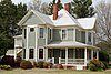 | July 18, 2016 (#16000451) | Centered along GA 42/US 23 between Hi-Hope Dr. & Grove Rd. 33°20′51″N 84°06′35″W / 33.347424°N 84.109793°W / 33.347424; -84.109793 (Locust Grove Historic District) | Locust Grove | |
| 11 | Locust Grove Institute Academic Building |  | September 4, 1986 (#86002179) | 3644 State Route 42//US 23 33°21′07″N 84°06′50″W / 33.35203°N 84.11402°W / 33.35203; -84.11402 (Locust Grove Institute Academic Building) | Locust Grove | Now city hall |
| 12 | McDonough Historic District |  | November 19, 2007 (#07001201) | Centered on Griffin St. and Keys Ferry St. 33°26′49″N 84°08′50″W / 33.447°N 84.147333°W / 33.447; -84.147333 (McDonough Historic District) | McDonough | The pictured gas station currently houses the McDonough Welcome Center, Main Street Program and McDonough Hospitality and Tourism, Inc Office |
| 13 | Walden-Turner House | 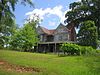 | April 9, 1980 (#80001093) | State Route 42/US 23 and Ward St. 33°32′40″N 84°13′58″W / 33.544444°N 84.232778°W / 33.544444; -84.232778 (Walden-Turner House) | Stockbridge | Last two-story Victorian house in Stockbridge. Demolished in 2006. |
References
- ^ National Park Service, United States Department of the Interior, "National Register of Historic Places: Weekly List Actions", retrieved June 7, 2024.
- ^ Numbers represent an alphabetical ordering by significant words. Various colorings, defined here, differentiate National Historic Landmarks and historic districts from other NRHP buildings, structures, sites or objects.
- ^ The eight-digit number below each date is the number assigned to each location in the National Register Information System database, which can be viewed by clicking the number.
Wikimedia Commons has media related to National Register of Historic Places in Henry County, Georgia.
| |
|---|---|
| Topics | |
| Lists by state |
|
| Lists by insular areas | |
| Lists by associated state | |
| Other areas | |
| Related | |
| |


