King tide
An especially high spring tide
A king tide is an especially high spring tide, especially the perigean spring tides which occur three or four times a year. King tide is not a scientific term, nor is it used in a scientific context.
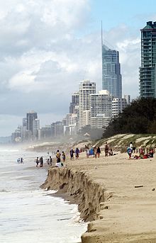
The expression originated in Australia, New Zealand and other Pacific nations to describe especially high tides that occur a few times per year. It is now used in North America as well,[1] particularly in low-lying South Florida, where king tides can cause tidal flooding. In Vancouver, Canada, king tides are a growing problem along its seawall.[2]
Definition
King tides are the highest tides. They are naturally occurring, predictable events.
Tides are the movement of water across Earth's surface caused by the combined effects of the gravitational forces exerted by the Moon, Sun, and the rotation of Earth which manifest in the local rise and fall of sea levels. Tides are driven by the relative positions of the Earth, Sun, Moon, land formations, and relative location on Earth. In the lunar month, the highest tides occur roughly every 14 days, at the new and full moons, when the gravitational pull of the Moon and the Sun are in alignment. These highest tides in the lunar cycle are called spring tides.
The proximity of the Moon in relation to Earth and Earth in relation to the Sun also has an effect on tidal ranges. The Moon moves around Earth in an elliptic orbit that takes about 29 days to complete. The gravitational force is greatest when the Moon is at perigee – closest to Earth – and least when it is at apogee – farthest from Earth – about two weeks after perigee. The Moon has a larger effect on the tides than the Sun, but the Sun's position also has an influence on the tides. Earth moves around the Sun in an elliptic orbit that takes a little over 365 days to complete. Its gravitational force is greatest when the Earth is at perihelion – closest to the Sun in early January – and least when the Earth is at aphelion – farthest from the Sun in early July.
The king tides occur at new and full moon when the Earth, Moon and Sun are aligned at perigee and perihelion, resulting in the largest tidal range seen over the course of a year. So, tides are enhanced when the Earth is closest to the Sun around January 2 of each year. They are reduced when it is furthest from the Sun, around July 2.[3]
The predicted heights of a king tide can be further augmented by local weather patterns and ocean conditions.
References
General references
- tidesandcurrents.noaa.gov
Inline citations
External links
- EPA King Tides Factsheet
- EPA page on king tides and climate change
- oceanservice.noaa.gov – NOAA National Ocean Service
- NOAA tool for predicting tide events –
- Tides and water levels – NOAA tides tutorial
- King tides photo initiative – North Carolina, US
- King tides photo initiative – Washington State, US
- King tides photo initiative – Oregon, US
- King tides photo initiative – Long Island Sound, US
- King tides photo initiative – Barnegat Bay, US
- King tides photo initiative – Australia
- King tides photo initiative – New South Wales, Australia
- www.thesinkingoftuvalu.com – King Tide / The Sinking of Tuvalu
- King tides photo initiative – Hawaii and Pacific Islands King Tides Project
- v
- t
- e
Physical oceanography
- Airy wave theory
- Ballantine scale
- Benjamin–Feir instability
- Boussinesq approximation
- Breaking wave
- Clapotis
- Cnoidal wave
- Cross sea
- Dispersion
- Edge wave
- Equatorial waves
- Fetch
- Gravity wave
- Green's law
- Infragravity wave
- Internal wave
- Iribarren number
- Kelvin wave
- Kinematic wave
- Longshore drift
- Luke's variational principle
- Mild-slope equation
- Radiation stress
- Rogue wave
- Rossby wave
- Rossby-gravity waves
- Sea state
- Seiche
- Significant wave height
- Soliton
- Stokes boundary layer
- Stokes drift
- Stokes wave
- Swell
- Trochoidal wave
- Tsunami
- Undertow
- Ursell number
- Wave action
- Wave base
- Wave height
- Wave nonlinearity
- Wave power
- Wave radar
- Wave setup
- Wave shoaling
- Wave turbulence
- Wave–current interaction
- Waves and shallow water
- Wind setup
- Wind wave


- Atmospheric circulation
- Baroclinity
- Boundary current
- Coriolis force
- Coriolis–Stokes force
- Craik–Leibovich vortex force
- Downwelling
- Eddy
- Ekman layer
- Ekman spiral
- Ekman transport
- El Niño–Southern Oscillation
- General circulation model
- Geochemical Ocean Sections Study
- Geostrophic current
- Global Ocean Data Analysis Project
- Gulf Stream
- Halothermal circulation
- Humboldt Current
- Hydrothermal circulation
- Langmuir circulation
- Longshore drift
- Loop Current
- Modular Ocean Model
- Ocean current
- Ocean dynamics
- Ocean dynamical thermostat
- Ocean gyre
- Overflow
- Princeton ocean model
- Rip current
- Subsurface currents
- Sverdrup balance
- Thermohaline circulation
- Upwelling
- Wind generated current
- Whirlpool
- World Ocean Circulation Experiment
tectonics
- Acidification
- Argo
- Benthic lander
- Color of water
- DSV Alvin
- Marginal sea
- Marine energy
- Marine pollution
- Mooring
- National Oceanographic Data Center
- Ocean
- Explorations
- Observations
- Reanalysis
- Ocean surface topography
- Ocean temperature
- Ocean thermal energy conversion
- Oceanography
- Pelagic sediment
- Sea surface microlayer
- Sea surface temperature
- Seawater
- Science On a Sphere
- Stratification
- Thermocline
- Underwater glider
- Water column
- World Ocean Atlas
 Oceans portal
 Category
 Commons


