Iganga–Tirinyi–Kamonkoli–Mbale Road
Major junctions
Tirinyi
Kamonkoli
The Iganga–Tirinyi–Kamonkoli–Mbale Road, also known as the Nakalama–Tirinyi–Kamonkoli–Mbale Road, is a road in the Eastern Region of Uganda, connecting the towns of Iganga in Iganga District, Namutumba in Namutumba District, Tirinyi in Kibuku District, Kamonkoli in Budaka District, and Mbale in Mbale District.
Location
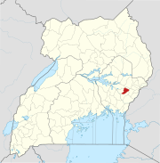
The road starts at Nakalama, a suburb of Iganga, on the Jinja–Tororo Highway, approximately 45 kilometres (28 mi) east of Jinja.[1] The road proceeds in a north-easterly direction, through Namutumba, Tirinyi, and Kamonkoli before ending at Mbale, a total distance of about 101 kilometres (63 mi).[2] The coordinates of the road at Tirinyi are 1°00'07.0"N, 33°45'51.0"E (Latitude: 1.001930; 33.764164).[3]
Overview
This road is an important national road, under the supervision of the Uganda National Roads Authority (UNRA).[4]
The road was upgraded to class II bitumen surface in 1995, with loan assistance from thean Development Bank]].[5] Since the upgrade, the road has been plagued by recurrent surface erosion, sinkholes, and vandalism.[6][7][8]
The government of Uganda (GOU), through UNRA, plans to fund a rehabilitation of this road. As of April 2015, the road rehabilitation project was classified as "Ongoing", fully funded by GOU.[9]
On 21 January 2022, the upgraded and resurfaced road was commissioned by Robinah Nabbanja, the Prime Minister of Uganda. The 99.3 kilometres (62 mi) single carriageway transport corridor was rehabilitated and improved to class II bitumen standard by Dott Services, fully funded by he Ugandan government. The rehabilitated road's projected lifespan is 15 years from date of completion.[10]
See also
References
- ^ Google (25 January 2022). "Distance between Jinja, Uganda And Nakalama, Uganda" (Map). Google Maps. Google. Retrieved 25 January 2022.
- ^ Google (25 January 2022). "Distance between Nakalama, Uganda And Mbale, Uganda" (Map). Google Maps. Google. Retrieved 25 January 2022.
- ^ Google (11 June 2016). "Location of Iganga–Tirinyi–Kamonkoli–Mbale Road" (Map). Google Maps. Google. Retrieved 11 June 2016.
- ^ TMN (2 November 2015). "Uganda National Roads Authourity Travel Notice - Traffic Diversion on Mbale-Tirinyi-Iganga Highway". Tendermarket.net (TMN). Retrieved 11 June 2016.
- ^ AfDB (30 June 2001). "Uganda Road Maintenance And Upgrading Project: Project Number: P-UG-DB0-014" (PDF). Abidjan: African Development Bank (AfDB). p. 8. Retrieved 11 June 2016.
- ^ Olupot, Milton (24 May 2010). "Uganda: Tirinyi Road Half Closed Over Stolen Culverts". New Vision via AllAfrica.com. Kampala. Retrieved 11 June 2016.
- ^ Vision Reporter (27 October 2015). "Namatala Bridge in Pallisa caves in". New Vision. Kampala. Retrieved 11 June 2016.
- ^ Yolisigira, Yazid (3 November 2015). "Iganga -Tirinyi Highway Closed". Daily Monitor. Kampala. Retrieved 11 June 2016.
- ^ UNRA (27 April 2015). "UNRA: Ongoing Major Projects". Uganda National Roads Authority (UNRA). Kampala. Retrieved 11 June 2016.
- ^ Charles Etukuri (21 January 2022). "Nabbanja commissions Nakalama-Tirinyi-Mbale Road". New Vision. Kampala, Uganda. Retrieved 25 January 2022.
External links
- Website of Uganda National Roads Authority
- Tirinyi Road In Namutumba District, Eastern Uganda As of 5 May 2016.
01°00′07″N 33°45′51″E / 1.00194°N 33.76417°E / 1.00194; 33.76417
- v
- t
- e

Capital: Mbale
villages

- Bumbobi–Bubulo–Lwakhakha Road
- Iganga–Tirinyi–Kamonkoli–Mbale Road
Tororo–Mbale–Soroti Road
- Absa Bank Uganda Limited
- Bank of Africa Uganda Limited
- Bank of Baroda Uganda Limited
- Centenary Bank
- Crane Bank
- DFCU Bank
- Equity Bank Uganda Limited
- Housing Finance Bank
- KCB Bank Uganda Limited
- Orient Bank
- PostBank Uganda
- Stanbic Bank Uganda Limited
- Standard Chartered Uganda
- United Bank for Africa
- Pride Microfinance Limited
- Finance Trust Bank
- FINCA Uganda Limited
landmarks
- Mbale Clock Tower
- Mbale Municipal Stadium
- Mt. Wanale
| ||
|---|---|---|
Capital: Budaka | ||
| Counties and sub-counties |
|  |
| Towns and villages | ||
| Economy | ||
| Banking | ||
| Transport |
| |
| Education |
| |
| Notable people | ||
| ||
|---|---|---|
Capital: Kibuku | ||
| Towns and villages |  | |
| Transport |
| |
| Notable people | ||
| ||
|---|---|---|
Capital: Namutumba | ||
| Towns and villages | 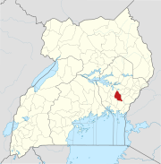 | |
| Transport |
| |
| Education |
| |
| Notable people | ||
| ||
|---|---|---|
Capital: Iganga | ||
| Towns and villages |
|  |
| Transport |
| |
| Banking | ||
| Health | ||
| Education | ||
| Notable people | ||


