Campo Alegre, Hatillo, Puerto Rico
Barrio of Puerto Rico
Barrio in Hatillo, Puerto Rico
18°24′59″N 66°47′08″W / 18.416432°N 66.785446°W / 18.416432; -66.785446[1] Puerto Rico
 Hatillo
 (2010)
Campo Alegre is a rural barrio in the municipality of Hatillo, Puerto Rico. Its population in 2010 was 5,210.[3][4][5]
| Census | Pop. | Note | %± |
|---|---|---|---|
| 1900 | 995 | — | |
| 1910 | 1,037 | 4.2% | |
| 1920 | 1,311 | 26.4% | |
| 1930 | 1,591 | 21.4% | |
| 1940 | 1,653 | 3.9% | |
| 1950 | 2,718 | 64.4% | |
| 1960 | 2,734 | 0.6% | |
| 1970 | 2,913 | 6.5% | |
| 1980 | 3,781 | 29.8% | |
| 1990 | 4,214 | 11.5% | |
| 2000 | 4,829 | 14.6% | |
| 2010 | 5,210 | 7.9% | |
| U.S. Decennial Census 1899 (shown as 1900)[6] 1910-1930[7] 1930-1950[8] 1980-2000[9] 2010[10] | |||
Gallery
-
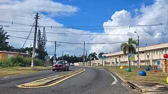 Puerto Rico Highway 130 in Campo Alegre
 -
 Puerto Rico Highway 134 in Campo Alegre


See also
 Puerto Rico portal

References
- ^ a b "US Gazetteer 2019". US Census. US Government.
- ^ U.S. Geological Survey Geographic Names Information System: Campo Alegre barrio
- ^ Picó, Rafael; Buitrago de Santiago, Zayda; Berrios, Hector H. Nueva geografía de Puerto Rico: física, económica, y social, por Rafael Picó. Con la colaboración de Zayda Buitrago de Santiago y Héctor H. Berrios. San Juan Editorial Universitaria, Universidad de Puerto Rico,1969.
- ^ Gwillim Law (20 May 2015). Administrative Subdivisions of Countries: A Comprehensive World Reference, 1900 through 1998. McFarland. p. 300. ISBN 978-1-4766-0447-3. Retrieved 25 December 2018.
- ^ Puerto Rico: 2010 Population and Housing Unit Counts.pdf (PDF). U.S. Dept. of Commerce, Economics and Statistics Administration, U.S. Census Bureau. 2010.
- ^ "Report of the Census of Porto Rico 1899". War Department Office Director Census of Porto Rico. Archived from the original on July 16, 2017. Retrieved September 21, 2017.
- ^ "Table 3-Population of Municipalities: 1930 1920 and 1910" (PDF). United States Census Bureau. Archived (PDF) from the original on August 17, 2017. Retrieved September 21, 2017.
- ^ "Table 4-Area and Population of Municipalities Urban and Rural: 1930 to 1950" (PDF). United States Census Bureau. Archived (PDF) from the original on August 30, 2015. Retrieved September 21, 2014.
- ^ "Table 2 Population and Housing Units: 1960 to 2000" (PDF). United States Census Bureau. Archived (PDF) from the original on July 24, 2017. Retrieved September 21, 2017.
- ^ Puerto Rico: 2010 Population and Housing Unit Counts.pdf (PDF). U.S. Dept. of Commerce Economics and Statistics Administration U.S. Census Bureau. 2010. Archived (PDF) from the original on 2017-02-20. Retrieved 2019-08-02.
External links
- U.S. Geological Survey Geographic Names Information System: Campo Alegre barrio
- v
- t
- e


