Bad Laer
Municipality in Lower Saxony, Germany

Coat of arms
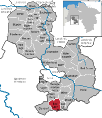
Location of Bad Laer within Osnabrück district
(2018–23) Tobias Avermann[1]
(2022-12-31)[2]
49196
Bad Laer is a municipality and health resort in the district of Osnabrück, in Lower Saxony, Germany. It is situated in the Teutoburg Forest, approx. 20 km south of Osnabrück.
The municipality includes Bad Laer and five outlying districts Remsede, Müschen, Hardensetten, Westerwiede and Winkelsetten.
References
- ^ "Verzeichnis der direkt gewählten Bürgermeister/-innen und Landräte/Landrätinnen". Landesamt für Statistik Niedersachsen. April 2021.
- ^ "LSN-Online Regionaldatenbank, Tabelle A100001G: Fortschreibung des Bevölkerungsstandes, Stand 31. Dezember 2022" (in German). Landesamt für Statistik Niedersachsen.
- v
- t
- e
Towns and municipalities in Osnabrück (district)
- Alfhausen
- Ankum
- Bad Essen
- Bad Iburg
- Bad Laer
- Bad Rothenfelde
- Badbergen
- Belm
- Berge
- Bersenbrück
- Bippen
- Bissendorf
- Bohmte
- Bramsche
- Dissen
- Eggermühlen
- Fürstenau
- Gehrde
- Georgsmarienhütte
- Glandorf
- Hagen
- Hasbergen
- Hilter
- Kettenkamp
- Melle
- Menslage
- Merzen
- Neuenkirchen
- Nortrup
- Ostercappeln
- Quakenbrück
- Rieste
- Voltlage
- Wallenhorst

Authority control databases | |
|---|---|
| International |
|
| National |
|
 | This Osnabrück district location article is a stub. You can help Wikipedia by expanding it. |
- v
- t
- e


